


Files
Download Full Text (648 KB)
Preview

Identifier
20192475
Description
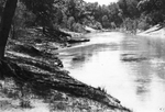
Trinity River 339.5 miles above mouth, 3 feet above low water, on left bank. Current is about two miles per hour and discharge is about 600 feet per section, downstream, 1976.
Archival Date
1976
Collection Name
U.S. Army Corps of Engineers Trinity River Records
Collection Number
AR909-6-144
Original Format
Negatives, Black & White
File Format
JPG
Rights
Rights held by The University of Texas at Arlington Libraries, Special Collections. Any use of content downloaded or printed from this page is limited to non-commercial personal or educational use, including fair use as directed by U.S. copyright laws. For more information or for reproduction requests, please contact UTA Special Collections by emailing spcoref@uta.edu.
License

This work is licensed under a Creative Commons Attribution-NonCommercial 4.0 International License