


Preview
Identifier
20035415
Description
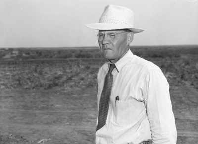
Deep production possibilities have been opened in eastern Fisher County at the Northern Ordnance, Inc., Number 1-B Howard 180, block 2. Houston & Texas Cental (H&TC) survey, producing from either the Strawn or Palo Pinto lime at 5,585 feet to 5,610 feet. On hand for the drilling in of the discovery is C. F. Palmer, owner of the land near the discovery. Published in the Fort Worth Star-Telegram morning edition, July 23, 1944.
Archival Date
1944-07
Collection Name
Fort Worth Star-Telegram Collection
Collection Number
AR406-6-613
Original Format
Negatives, Black & White
File Format
JPG
Rights
Rights held by The University of Texas at Arlington Libraries, Special Collections. Any use of content downloaded or printed from this page is limited to non-commercial personal or educational use, including fair use as directed by U.S. copyright laws. For more information or for reproduction requests, please contact UTA Special Collections by emailing spcoref@uta.edu.
License

This work is licensed under a Creative Commons Attribution-NonCommercial 4.0 International License
Subjects
Northern Ordnance, Inc.; Palmer, C. F.; Petroleum industry; Oil wells; Meadows
Subjects
Northern Ordnance, Inc.; Palmer, C. F.; Petroleum industry; Oil wells; Meadows